Horus 45 Balloon Flight for WIA Convention 2017 – Preparation Underway!

The Amateur Radio Experimenters Group is please to announce that it will be supporting the WIA AGM & Convention weekend with a balloon launch. This launch will take place from Hahndorf Oval, as part of the “Come and Try Radio” activities day to be held on Sunday 21st May.

This event is aimed at promoting the many different facets of Amateur Radio and giving people the opportunity to learn about how to get involved. AREG will be manning two complete tracking stations at the event, one a fixed ground station and the other will be one of the chase cars decked out in the equipment we use to chase balloons in.

The main aim is to get more people interested in tracking the balloons!


Flight Payloads

The payloads are still being finalized, as the jet-stream has returned and there are concerns that the flight could be carried downrange much further than planned.

Balloon Repeater Frequencies

The balloon repeater will be heard on:

  • INPUT: 145.775MHz with 91.5Hz CTCSS (+/- thermal drift of the receiver)
  • OUTPUT: 438.850MHz (+/- thermal drift of the transmitter) – 0.8W into 1/4wave omni

NOTE 1: The VHF frequency has changed this flight to avoid harmonic issues with the Wenet imaging payloads

NOTE 2: The repeater is built out of a received designed to receive Narrow FM (12.5kHz bandwidth) not the usual 25kHz wideband FM that amateurs use. Please keep your deviation down so that you can pass through the repeater without it closing it’s mute.

To transmit to the balloon at the maximum range of 800km (once the balloon reaches 100,000ft ++) you should only need approximately 10-20W and an 2-4dB gain antenna.

Receiving the balloon at 400km range in a handheld environment should be achievable, but to hear the repeater at the maximum range of 800km you should expect to need a 10dB gain Yagi for a 0.4uV capable receiver and 2dB feeder loss

This setup is much the same as the LEO satellites but without the high speed Doppler shift.

PLEASE MAKE SURE YOU CAN HEAR IT BEFORE YOU TRANSMIT!

Other Balloon Payloads

Other payloads being flown on this flight will include:

  1. our standard 100bps 7N1 RTTY telemetry transmitter on 434.650MHz, and
  2. the Wenet imaging payload which will downlink on 441.2MHz at 115Kbit/s, and which will stream HD photos during the flight.

Images can be seen (here).

Tracking will again be available via www.habhub.org

Flight Time and Launch Location

If you would like to learn more about how to get involved in tracking the balloon, take a look at the following resources on the club website, or come on down to the launch on Hahndorf Oval. Preparations will begin around 1.00pm, with liftoff planned for 2.00pm. (See the location marked “Amateur Radio Come and Try Day”.


WIA AGM & Convention Special Event Callsign to be Net Control on the balloon repeater

The WIA AGM & Convention special event call sign VK5WOW and VI5WOW will be heard via the balloon repeater during the event. Contacts with VI5WOW and VK5WOW through the balloon will qualify for the award certificate.

Full details of the Convention 2017 award are available via  www.wia.org.au/members/wiaawards/agm2017/

UPDATE: Overland Corner Balloon Launch – Sat 22nd ~11am

Predicted Balloon Flight Track as at 7am 20th April

Preparations continue for the High Altitude Balloon launch, scheduled for Saturday morning from Overland Corner in the Riverland district of South Australia. This flight is one of the events that is planned as part of the BRL Weekend for the Riverland Radio Club.

The flight track prediction has been quite unstable for a few days but now has settled down into a reasonably accessible area near Renmark. This launch is being conducted in conjunction with the Riverland Radio Club’s BRL Weekend event at the Overland Corner Hotel.

Amateurs from across SA, VIC and NSW are invited to take part in one of the many amateur Radio facets of this flight, from receiving and relaying the telemetry, making contacts through the new balloon repeater and monitoring either direct or via the Internet the Wenet HD imagery payload.

Balloon Repeater Frequencies

This is the first test flight of a new experimental cross band voice repeater that has been built with weight in mind to fly under our balloons.The balloon repeater should be heard on:

  • INPUT: 147.500MHz with 91.5Hz CTCSS (+/- thermal drift of the receiver)
  • OUTPUT: 438.850MHz (+/- thermal drift of the transmitter) – 0.8W into 1/4wave omni

Please note that this repeater is experimental, and may have performance issues during the flight.

To transmit to the balloon at the maximum range of 800km (once the balloon reaches 100,000ft ++) you should only need approximately 10-20W and an 2-4dB gain antenna.

Receiving the balloon at 400km range in a handheld environment should be achievable, but to hear the repeater at the maximum range of 800km you should expect to need a 10dB gain Yagi for a 0.4uV capable receiver and 2dB feeder loss

This setup is much the same as the LEO satellites but without the high speed Doppler shift.

PLEASE MAKE SURE YOU CAN HEAR IT BEFORE YOU TRANSMIT!

Additionally, the receiver used in the repeater (a Dorji DRA818) appears to have quite sharp receive filters, which results in the repeater dropping out if the input signal is over-deviated (>4.8 kHz dev). Please talk using a regular speaking voice when using the repeater to avoid issues.

Special Event Callsign via the Balloon

As part of the WIA AGM & Convention weekend promotion, we also hope to activate VK5WOW, the special event callsign for that event, via the Balloon Repeater!

Contacts with the special event callsign via the balloon will qualify towards the Convention Award. The flight payloads will be one of the topics presented at the convention by Mark VK5QI, so make a contact through the balloon and then come on down to Hahndorf between May 19-21st to hear about how Project Horus flys and how you too can get involved in this fascinating aspect of the hobby!

Other Balloon Payloads

Other payloads being flown on this flight will include:

  1. our standard 100bps 7N1 RTTY telemetry transmitter on 434.650MHz, and
  2. the Wenet imaging payload which will downlink on 441.2MHz at 115Kbit/s, and which will stream HD photos during the flight.

Images can be seen (here).

Tracking will again be available via www.habhub.org

If you would like to learn more about how to get involved in tracking the balloon, take a look at the following resources on the club website.

Caveats – The weather may beat us

There is a small wrinkle in the plans currently and that is the weather. There have been significant rainfalls across the region in the last few days which may have made many of the dirt roads we might need to use impassable. The team is monitoring the situation and will advise if we have to call it off due to access. It currently depends on where the landing zone ends up. Stay tuned, and understand we are trying to plan a way to ensure we do get into the air on Saturday!

Horus 41/42 Flight Report: Southern Hemisphere Space Studies Program Jan 2017

Introduction

For the second year running, the Amateur Radio Experimenters Group was invited to partner with the University of South Australia and the International Space University in delivering the Southern Hemisphere Space Studies Program. This program, which is a 5 week intensive live in course offered by the universities to students from around the world, is designed to meet the needs of:

  • Professionals seeking more knowledge of and contacts in the international space sector

  • Graduate researchers in all fields seeking a broader knowledge of international space activities and the disciplines involved

  • Undergraduate students in the final two years of their studies seeking exposure to the various aspects of space studies to complement their undergraduate studies

* Extracted from the ISU Website

Part of the program comprises a simulated satellite launch campaign using a high altitude helium balloon platform, flown using the resources of the Amateur Radio Experimenters Group and Project Horus, which are based here in Adelaide. This in fact marks the 7th year of the group’s High Altitude Balloon Project, which was the brainchild of Terry Baume VK5VZI.

Like many of the Horus launches, this one again sought to strengthen ties with programs that are related to Science, Technology, Engineering and Maths (STEM) in education. Bringing Amateur Radio into context with space studies and education helps highlight the huge diversity of the Amateur Radio service and it’s absolutely unique place in the Australian technology landscape. No other radio-communications service provides an opportunity for interested persons from a huge diversity of backgrounds to come together and undertake cutting edge explorations into communications technology.

ISU: Project Space Balloon

The project this year was set some very ambitious goals. Built on the success of last year’s flight, and the newly designed high speed transmission link capability designed by Mark VK5QI, with help from David VK5DGR and Bill VK5DSP, the plan this year was to send aloft two balloons simultaneously, carrying look down cameras observing in both the visible and near infrared spectrum. The aim was to conduct investigations into water resources through remote sensing imagery. These payloads were to downlink their data in real time over the Wenet 115kbit/s telemetry links. A third Wenet payload with an outward looking camera was also flown.

The students were then mentored through the construction of the second Wenet payload by Mark VK5QI and Matt VK5ZM. They were also given training in flight prediction, launch and recovery procedures by Matt and Grant VK5GR and were given opportunities to be involved in every aspect of the flights.

Ultimate launch control, tracking and recovery was then the responsibility of the AREG team, with over 20 members involved in some aspect of the flight, as well as many more amateur radio operators across South Australia who all contributed to receiving telemetry information from the balloon, which helped with the payload recovery efforts.


The Launch Campaign: Horus 41 – McLaren Vale

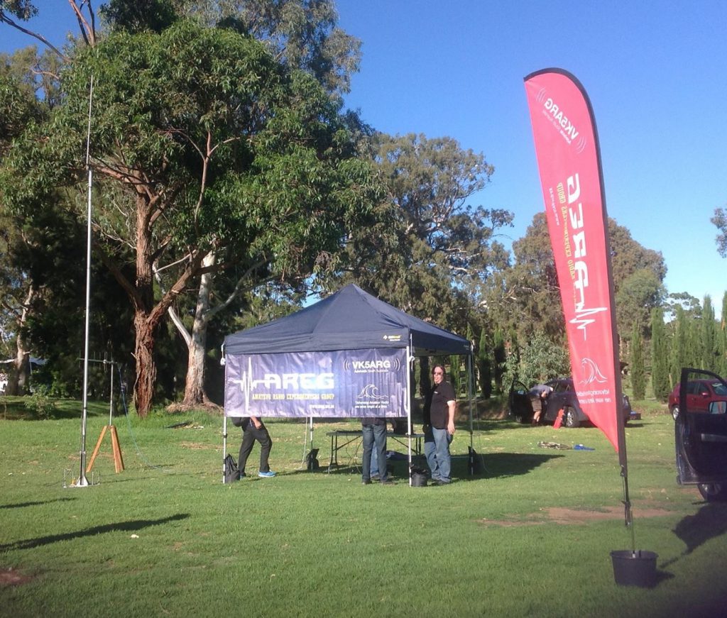
The day began early, with the AREG and University teams arriving at Serafino’s Winery in the picturesque McLaren Vale region at 8.00am. The first order of business was to unpack the balloon filling station, and then setup the Wenet SSDV receive ground station, which was to be used later in the day to capture the 115kbit telemetry from Horus 41 and relay it into the publicity event at the winery. Horus 41 ground was to be manned by Paul VK5BX and Bill VK5DSP (from UniSA), with much of the equipment supplied by Matt VK5ZM.

Matt and Chris VK5CP were also heavily involved in the publicity engine throughout the day, with Matt again proving adept as master of ceremonies during the launch, describing to the spectators what was happening and the overall process of getting the balloon in the air. He also played a major role in the formal part of the SHSSP program, giving a formal 10 minute presentation on the AREG, Project Horus and Amateur Radio to 100+ guests and VIPs invited to attend the launch.

The payloads were then laid out in order and the balloon train was prepared, with students helping the AREG team along the way. Some extra payload was added in the form of Serafino wine grape seeds, which will subsequently be planted to see if exposure to high altitude changes their character at all many years down the track.

Next, balloon filling got underway and the ISU student team set about helping Grant VK5GR, Andrew VK5XFG, Josh VK5JO and Sharon VK5FSAW getting the balloon filled and readied for launch. Horus 41 was to use a Totex balloon and was carrying approximately 1.2kg in payload weight.

The count down began and everyone kept an eye on the time, knowing that the team in Mt Barker were doing the same thing. We aimed to lift off at 10:00am, but due to some difficulties with the balloon filling equipment, this was delayed slightly. The count down went on hold while this was rectified, and then we resumed. By 10:02am everything was ready, and launch release was placed into Matt VK5ZM’s hands.

Contact was then made with Launch Team 2 up in Mt Barker to confirm how their preparations had run.

The Launch Campaign: Horus 42 – Mt Barker

The Mt Barker launch was a more low key affair, with just the ISU students and the AREG launch team. Mark VK5QI lead operations at Mt Barker, helped by Kim VK5FJ, Dennis VK5FDEN, Anthony VK5AHV, David VK5DGR, Andrew VK5AKH and Gary VK5FGRY. Horus 42 was using a larger Hwoyee Balloon as the flight path was predicted to encounter fewer obstacles.

Horus Ground Control Strathalbyn comes Online

An unseen to the public but vitally important part of the exercise was the work being undertaken by Peter VK5KX and Scott VK5TST to provide a primary ground station for collecting the Wenet imagery. Peter found himself a suitable location on the SE edge of the Mt Lofty ranges and setup the communications bus. It served two purposes, with the first being the telemetry reception and internet uplink, but the second was also recovery team liaison on VHF amateur radio (2m). Repeater coverage in the landing zone was very poor, so simplex relays were used to maintain team communications.

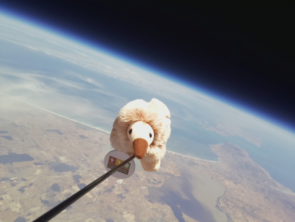
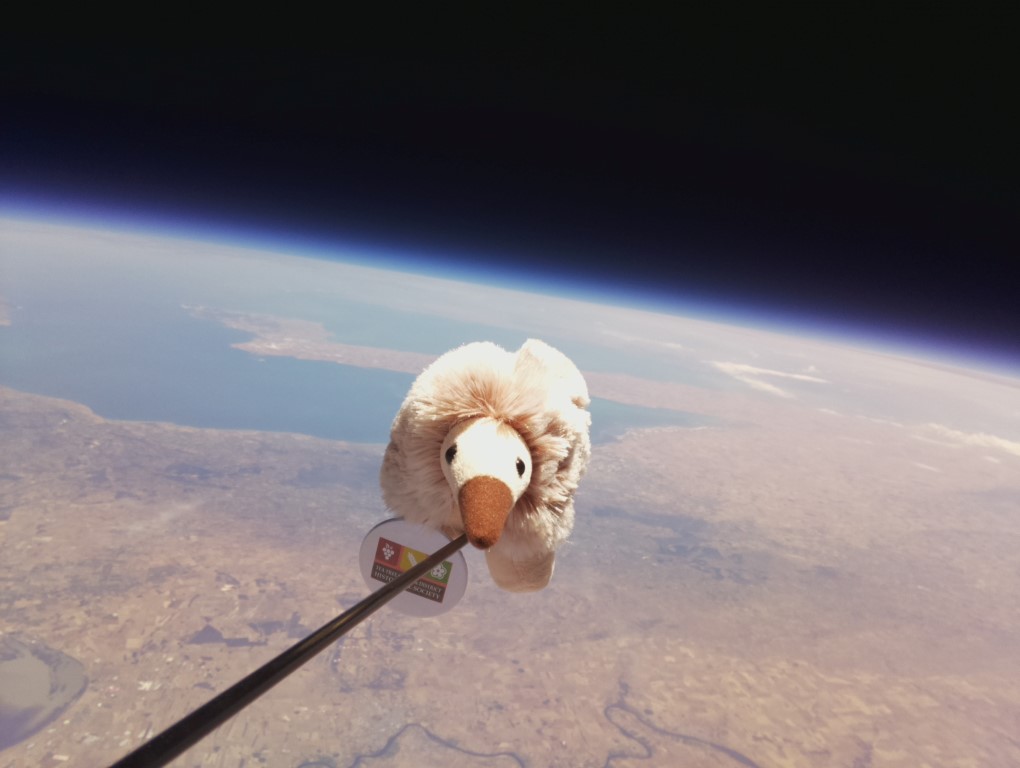
Liftoff for SHSP 2017 – Tracking begins

Finally at 23:45UTC (10:15am) both Horus 41 and Horus 42 made it into the air. At the last minute, the ground winds sprung up at Mt Barker, causing some consternation. The launch was held for 2 minutes while the team waited for the winds to abate, and then we took to the skies. Telemetry started to stream in as the balloons gained height and more distant stations could receive the signals. Images were being received too and all looked good for two successful flights.

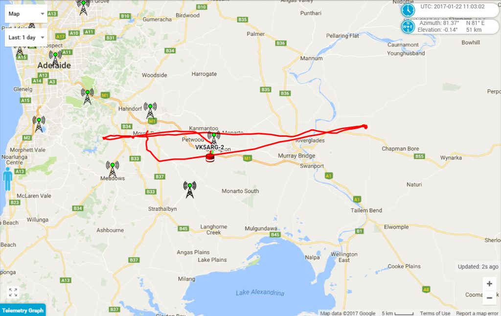
Shortly after lift off, however, the first wrinkle appeared in our plans. High Altitude Ballooning is never an exact science, and today wasnt going to be an exception. It turned out Horus 41 wasnt climbing as fast as intended and the low altitude winds were pushing it further south than planned. This was bad news, as it greatly increased the risk of a landing in Lake Alexandrina (and the consequential loss of the payloads) instead of on the open plain to the north of it.

An anxious hour followed where the predictor was watched very closely, tracking height, and the actual landing zone if the flight was stopped at any particular moment. Fortunately the track drifted north and we started to breath easier, once we passed 31km altitude and had removed the lake from the landing equation.

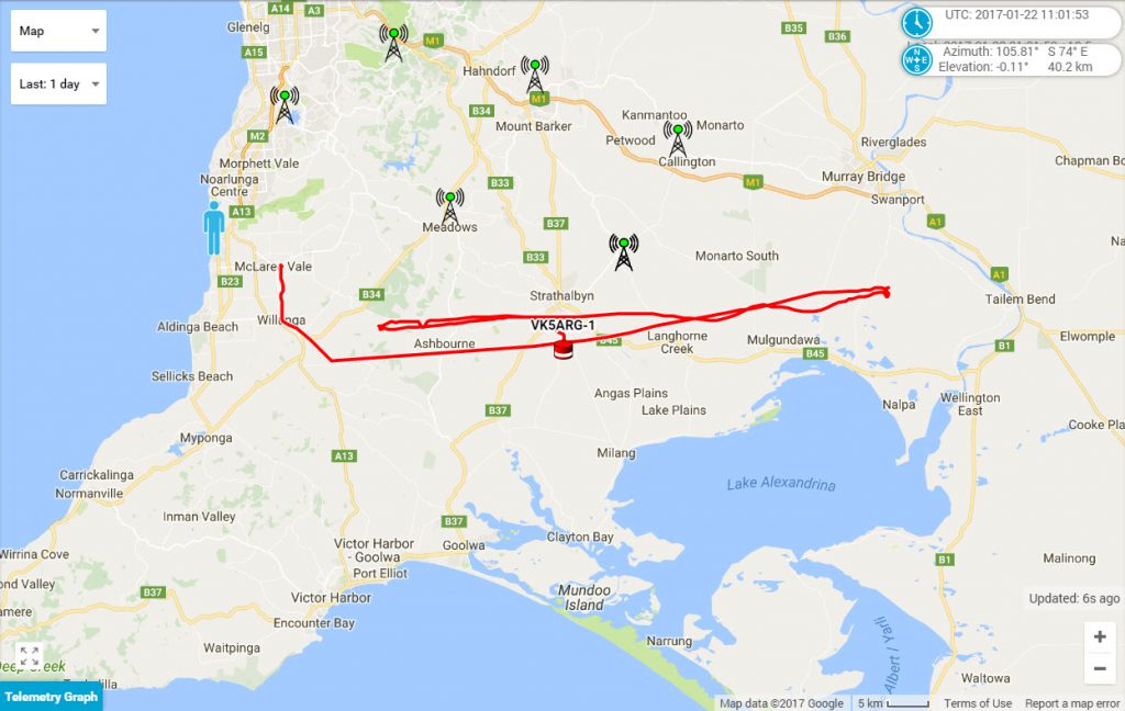
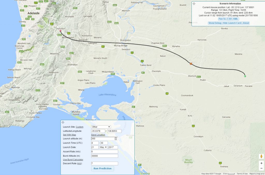
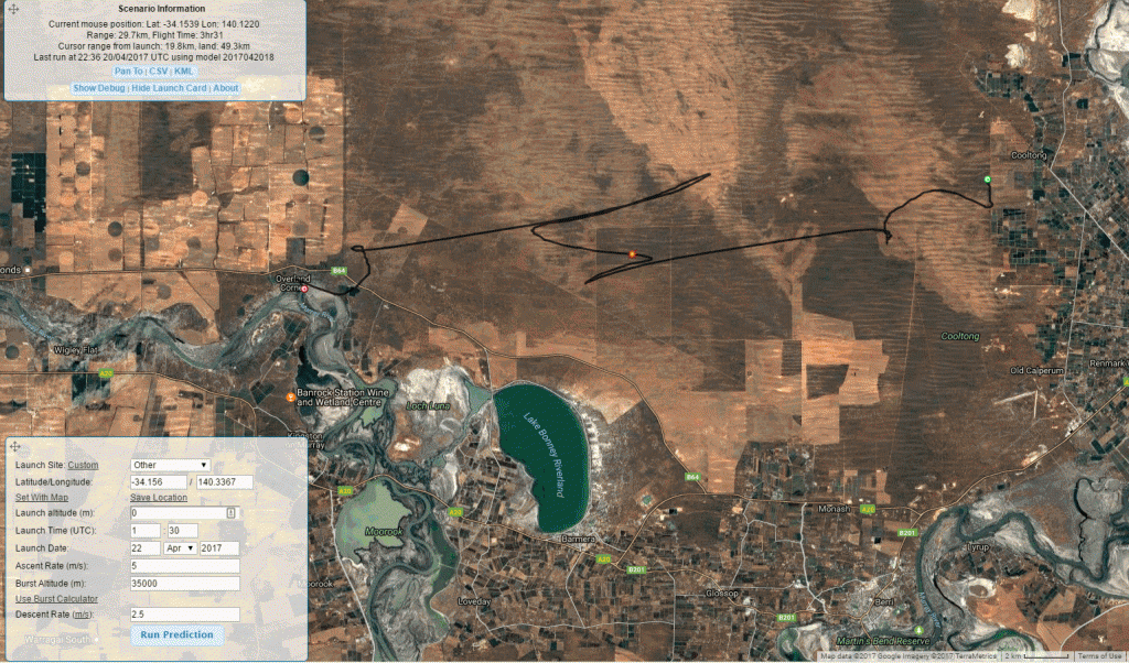
Horus 42 had an easier time, although it too had obstacles to avoid. One of the problems of summertime flying was that the jet stream was quite weak, and so flights don’t travel as far east as the team would prefer. Recovery in the Adelaide hills is never easy due to access and terrain. It’s flight track looked as follows:

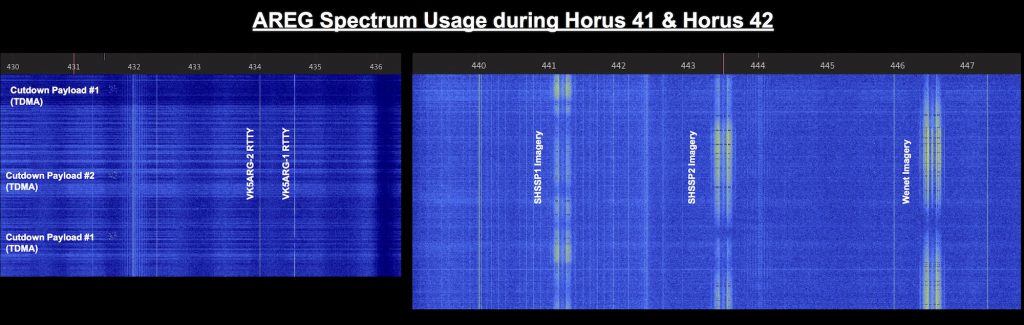
This was also one of the most complicated flight campaigns AREG and Project Horus has undertaken. All up we had 2x LoRA transmitters, 2x RTTY transmitters and 3x 115Kbit Wenet transmitters on air on 70cm at the same time! This spectrum display shows how we were spread out across the Amateur 430-450MHz band – where we had to borrow space from the ATV and repeater link segments to accommodate everything.

This puts the amount of work into perspective in constructing and operating all of these facilities.

The reception of all of these telemetry feeds was only made possible by the contributions from amateur radio operators across the state. Those recorded in the system has having contributed telemetry frames were:

Horus 41 RTTY – VK5QI-9, VK5ZM, VK5AKK, VK5ZRL, VK5DF, VK5EI2, VK5NEX, VK5KIK, VK5PJ, VK5ZLX, VK5HS, VK5DMC, vk5ftaz, VK5DF/p, VK5EI, VK5KX, VK5DC, VK5FJGM, VK5ALX, VK5RR, VK5EU, VK5PJ/P

Horus 42 RTTY – VK5AKH, VK5AKK, VK5KJP, VK5KIK, VK5ZEA, VK5DC, VK5PJ, VK5KX, VK5RR, VK5DF/p, VK5ALX, VK5DF, VK5DMC, vk5ftaz, VK5HS, VK5ZLX, VK5TST, VK5EU

SHSSP1 SSDV: VK5DSP,VK5ZM,VK5FI

SHSSP2 SSDV: VK5AKH,VK5KX,MI0VIM,VK5RR

The AREG and SHSSP thank you all for your interest in the project and your contributions to the tracking and telemetry effort.

A special thank you too to Phil Heron MI0VIM who was in Australia this week and flew across to Adelaide especially for this event. For those who didn’t realize, Phil is one of the creators of the HabHub system that the UK High Altitude Society built that is used by Project Horus to support our flights.

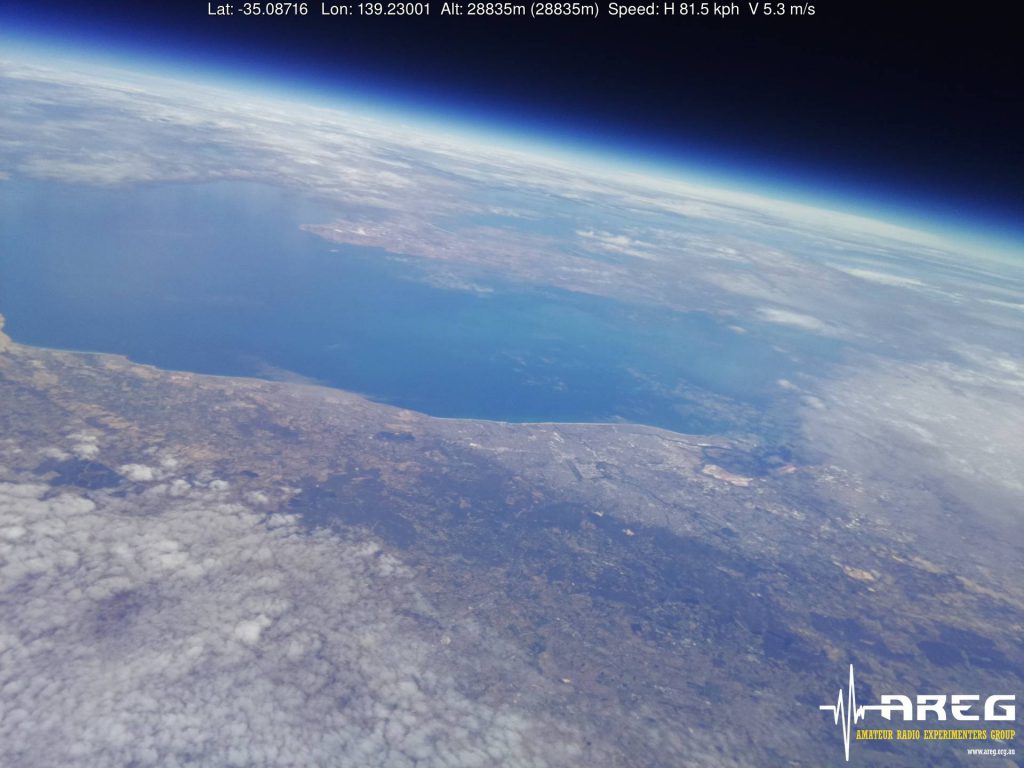
And then the Images Flooded In…..

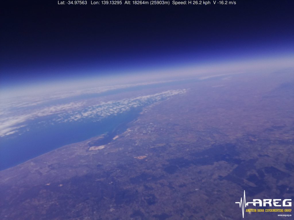
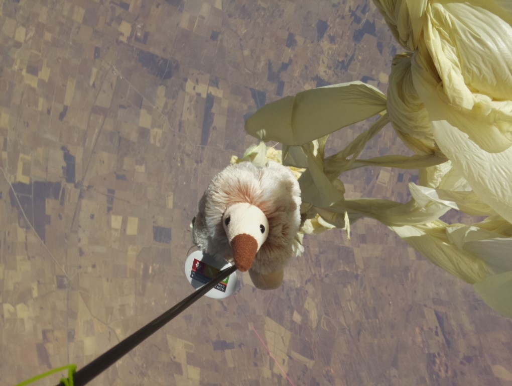
Once the payloads were in the air, the real business got underway. The pictures being retrieved were spectacular:

Horus 42 – Wenet Outward Looking Visible Spectrum

This slideshow requires JavaScript.

Horus 41 – Near InfraRed Images

This slideshow requires JavaScript.

Horus 42 – Near InfraRed Images

This slideshow requires JavaScript.

Recovery – Horus 41

The recovery of Horus 41 was very easy (for a change) with the payload landing on a service track that we could easily get to within 100m by car. Touchdown was ~1km from the tracking team, although we weren’t lucky enough to catch a glimpse of it in the air. After the land-owners were approached, access to retrieve the payloads was obtained. Three of the SHSSP students plus the AREG Horus 41 tracking crew collected the payloads, and then as a surprise for the organizers were able to deliver them back to the launch venue and present them to the VIPs prior to the conclusion of their event.

Recovery – Horus 42

Horus 42’s flight recovery was also successful, although it did come close to landing on a major road! In the case of Horus 42, they were there to see the landing live! No small achievement (only about 1 in 5 flights are we there at the exact landing site).

Flight Statistics – Horus 41

[table “” not found /]

Flight Statistics – Horus 42

[table “” not found /]

Conclusion

All told, the day was considered a complete success. Both balloons achieved greater than 30km altitude, the images were successfully collected over the air on the Wenet network and 23 separate amateur stations across South Australia were involved in collecting tracking information.

The goals of Project Horus’s engagement with the Southern Hemisphere Space Studies Program in bringing Amateur Radio into education were met and then some! It was fantastic again working with the crew at the University of South Australia, and we hope that AREG is again invited back next year!

Keep Watching…

Stay tuned for a further blog post this week with some video animations of the tracking and some film clips of the launch and landing activities too! More to follow…..

Horus 39: December 3rd 2016 Flight Report

logottgc


On Saturday December 3rd 2016, the Amateur Radio Experimenters Group launched the Tea Tree Gully Library mascot, Anstey the Echidna into the stratosphere as part of her next big adventure. In the past 12 months Anstey the Echidna has been to France, Italy, Ireland, Japan and New Zealand.

Flying an Echidna into near space is not without its challenges. It took a very large team of people from the Project Horus group within AREG, as well as a large number of amateur radio operators from across SE Australia to achieve this feat.

Launch Preparations

The first stage of the journey was to build the craft that would carry Anstey into the stratosphere. Mark VK5QI and Matt VK5ZM worked some long hours preparing the vehicle to make sure that not only would Anstey get a perfect view, but that those of us on the ground could also share her experience.

The cameras used included a GoPro Hero 3 and a Raspberry PiCam connected to the Wenet 115kBit/s 50mW data transmitter. This was only the second full flight of the Wenet system which has been co-developed by Mark VK5QI and David VK5DGR using an FSK modem developed by the team with help from Bill VK5DSP. (more on this shortly).

Balloon Launch Crew

On the ground, we had a large contingent of members from the Project Horus team. Matt VK5ZM lead the assembly of the balloon payload train while Mark VK5QI, Grant VK5GR, Kim VK5FJ and Gary VK5FGRY set about filling the balloon.

After the “Balloon meets tree” incident during Horus 38, we added an extra safety measure, with the release of a sounding balloon before the main launch.Grant VK5GR’s daughter, Amelia, did the honors.

Finally, the team from the Tea Tree Gully council started their Facebook live broadcast back to mission control and we prepared to send Anstey off into the sky on her epic journey.

Mission Control – Tea Tree Gully Library

Back at the library the staff had setup vk5bb-library“mission control” for the morning. Ben VK5BB and Olga VK5FOLG from AREG represented our club at the library and introduced themselves to David Brooks who organised the event. Ben goes on to report:

“David then performed the introductions, giving a little bit of history of the Tea Tree Gully area and how he believes that the local population growth was tied to events within both the USA and USSR space programs. In the back ground we were watching a number of video clips from the Launch site, looking at the equipment, Matt explaining what all the equipment in his vehicle was for, Mark explaining the tracking facilities in his car and the reporter doing his bit at launch time. 

David then introduced  Dr. Brent Gooden who was an expert in a number of fields, space suits, space medicine and Echidnas! He talked about how the Echidna was very well adapted physiologically wise to be able to take the rigors of space travel, all tongue in cheek but very well presented. Mean while on the wall behind the speakers, the images of Anstey were being displayed as they downloaded. Very nicely done!

Then I was invited to the rostrum to give a plug for AREG. I spent about 5 minutes talking about the history of AREG, Project Horus, that AREG was a “young” club and have a focus on radio technology and encouraging young people to look at STEM in their education which was well received.

I was well thanked by David and he publicly acknowledged that without AREG and Project Horus, this event would not have happened.”

Flight Ground Tracking Network

The next major component of the event was the flight ground tracking network. To retrieve the transmitted images from the balloon, we had positioned several stations around the state equipped with RTL-SDR dongles, pre-amps and the receiving software designed to collect the Wenet 115kBit/s telemetry stream. Station No.1 was Peter VK5KX and his partner Wendy, who camped on top of a hill overlooking Palmer on the eastern face of the Adelaide Hills.

tracking-data-recovery-centre-vk5kx

Ground Control Palmer – VK5KX

vk5kx-tracking-central

Ground control inside VK5KX

Peter reports “Wendy & I drove up to Palmer Saturday morning. We had to do some extra km’s due to chain of ponds road being closed, however we got there and rushed the setup completing everything in a nick of time. We were getting SSDV images before we had a lock on the balloon RTTY payload.

just_before_landing-mediumPointing the 5 element 70cm beam at a point in space to Rx the SSDV images was no easy task. I tried using a compass app on the phone, even a Theodolite app, but they were both giving erroneous readings, so I reverted back to a handheld magnetic compass. I did mange to get used to it and made a few notes as to where to point the beam and at what angle of elevation.  Some perfect images were decoded and uploaded.

After the balloon burst, we manageburst_and_parachute-mediumd to track it for some time before starting to have some issues decoding the RTTY. I could see the data clearly but the fl-digi window stayed red, only occasionally going green. To be investigated later. We went on to camp on the hill that night in preparation for Horus 40 on Sunday morning.

When Sunday arrived, the weather appeared with a vengeance. The winds
were so fierce that they nearly blew us away. It did managed to blow some seats and gear down the hill. Unfortunately in it’s path was the beam antenna on it’s tripod. I now need to do some maintenance on the beam.  I notified the Sunday launch crew that we were pulling the plug and then the fun began as we tried to expediently get all the gear in the bus somewhere. Then the rain started too, as I ventured 2/3 the way down the hill to retrieve a red plastic box, the trip back to the bus against the wind & uphill wasn’t pleasant…..”

Bob VK5FO and Ray VK5RR operated ground control No.2 from their home near Waikerie in the Riverland. Bob reported:

“at the last minute before the Launch, we were able to borrow an RTL-SDR and Pre-Amp in order to set up an additional station to RX the SSDV pictures from the Balloon. The RX station was set up in the Riverland, near Waikerie and was reporting Telemetry and Image data as VK5RR.

20161202-141417z-medium 36km_altitude_pic-medium

Given that the site was about 100km+ away from the flight path, it was actually an unknown if it would even RX any data. We monitored the flight data and once the Balloon hit around 6,000M we started to RX some telemetry. It was noted that once the signal got to around 6 or 7db above the noise floor it was getting consistent decodes.

Now, the Antenna used was not ideal – it is a typical “white stick 2/70 Dual band antenna, around 25M of RG-213 before the Pre-Amp. Once we were getting good decodes the RX site was left  unattended for the rest of the flight. We contributed to the image data on SSDV.habhub.org and noticed that at around the 27,000m mark  we lost RX of the image signal.  This was probably a null in the Antenna – given that this was probably around the 25 Degrees elevation from the RX location.

After the Balloon burst, we again started to RX Image data, and this time it was right down to approx 2,000M (at over 140km away).

On checking the recorded images, we had partial data on several, and nearly 100% of others.  A total of 127 Images (complete and partial) were received, and a total of 253 images of the flight were recorded and uploaded.  The RX site provided image data for around 1/2 of the images of this flight.”

We also had Kim VK5FJ receiving the balloon from Mt Barker as well as the two mobile recovery vehicles with VK5QI and VK5ZM, all who contributed some data to the successful images relayed back to Mission Control live from the balloon.

The following animation is compiled from the still images collected from the balloon SSDV telemetry system.

More details about the Wenet system designed by the Horus team and the SSDV platform provided by UKHAS and Phil Heron can be found elsewhere on the AREG site.

Flight Statistics

The flight itself was almost a text book affair. The flight track can be seen in the following animation created by Grant VK5GR from the telemetry raw data.

The vital statistics are:

[table “” not found /]

The team would like to thank all of the following stations for their contribution to the  telemetry collection effort:

VK5APR, VK5EU, VK5FTAZ, VK5KJP, VK5KX, VK5NEX, VK5PJ, VK5QI, VK5RR, VK5ZEA, VK5ZM

Recovering Anstey – in a field of Triticale

burst-mediumThe final act was for the balloon to burst and for Anstey to return to earth to tell her tale. The mobile tracking crews, based on the available predictions, had headed for Lameroo in the Murray Mallee about 250km east of Adelaide. Once the balloon burst however, we discovered that it was falling faster than predicted.

We determined that again the burst hadn’t been a clean one (confirmed with one of the SSDV images we collected) and along with the payloads, a large chunk of the balloon was coming back still attached! The drag of the parachute slowed the descent, but not as slow as originally planned, with the payloads eventually returning to earth at ~9m/s. This caused something of a scramble among the tracking teams as the landing suddenly looked to be about 30km short of where we expected. Fortunately, we weren’t that far away when it touched down, and a good fix from the beacons was obtained before the landing.

After about 20 minutes, we had located the land owners, who were curious to see what we had landed on their property. They were very helpful and friendly farmers who lead us to the landing site in our vehicles. We should have been able to drive right to the payload, except at the critical moment, the telemetry computer crashed in the VK5ZM chase car. So, out with the yagi and direction finding gear to find Anstey the old fashioned way.

After a further 15 minutes, and a hike across a 1m high crop paddock, Anstey was found safe and well.

Conclusion

Everyone declared Horus 39 a success, and looking at the comments and feedback received via social media, it would appear it was very well received by the amateur radio community across Australia as well. We are looking forward to the next time we can fly and hope you will come on the journey too! 73 de Project Horus, Adelaide!

Next Meeting: Friday Nov 25th: Live Balloon Imaging System

Note: Changed meeting week this month – 4th Friday (not the normal 3rd)

SSDV Experimental Payload – ‘Wenet’

Mark VK5QI and David VK5DGR have been working on a slow scan digital image payload for the balloon system which transmits at 115kbit/s on a new downlink channel. This system makes uses of the UKHAS SSDV server to stitch together images from packets uploaded by multiple receivers. You can read more about the system on Mark VK5QI’s blog.

Unlike analog SSTV, SSDV sends down compressed JPEG images via some form of data link. Written by Philip Heron, the SSDV software converts a JPEG image into a set of packets which can be transmitted via a radio link and then re-assembled on the ground. Unlike regular JPEG images, if a packet is lost, SSDV will still produce a full image, albeit with some portions missing.

Wenet RX software running within a Ubuntu Virtual Machine

At the meeting Mark and David will give you an insight into how it works. This system will be demonstrated in the field as well during coming Horus flights.

Meeting Time

The clubrooms will be opened from 7.45pm with the presentation starting at 8.00pm. Visitors are most welcome! You will find us here:

[wpgmza id=”5″]