
In January 2023, the Project Horus High-Altitude Ballooning group performed two launches, Horus 58 on the 15th of January, and the Southern Hemisphere Space Studies Program 2023 launch, on the 29th of January. This is the first of two flight reports, with the SHSSP 2023 report coming soon!
Horus 58 – Test Flight – 15th January 2023
The Horus 58 launch was intended as a flight test of the payloads to be used in the SHSSP 2023 launch, and included:
- 2x Horus Binary telemetry payloads, one with a radiation sensor.
- Outward-Facing Wenet Imagery
- Nadir (Downward) Facing Wenet Imagery, with an IR filter
- LoRaWAN Telemetry Beacon (not used in the SHSSP launch)
In particular, the radiation sensor payload (using a Geiger-Muller Tube) and the Nadir-Facing imagery payload were newly built and needed to be flight-proven to limit the chances of failure on the upcoming SHSSP 2023 launch. Also flown was a LoRaWAN payload built by Liam VK5ALG, which was received by TheThingsNetwork gateways.
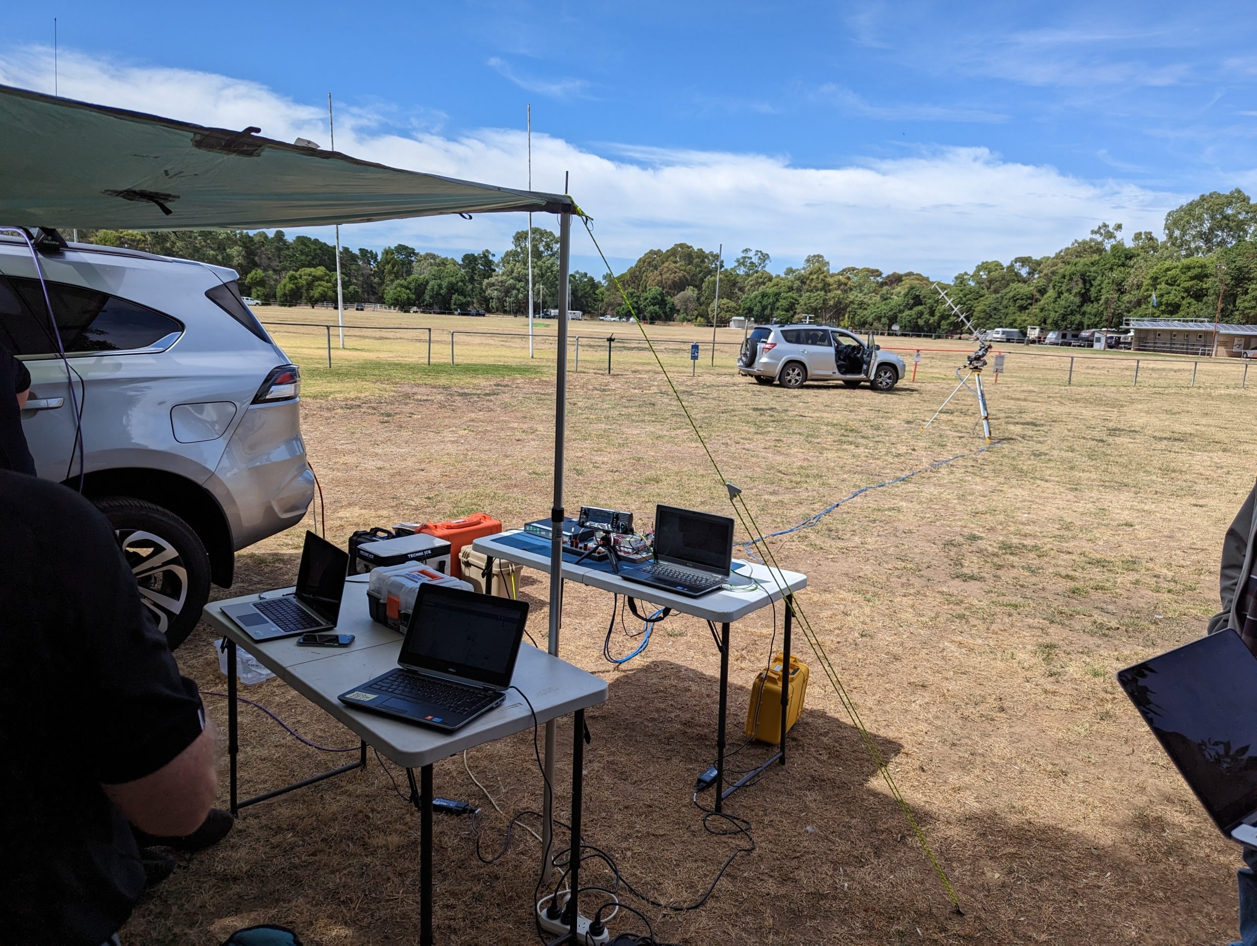
Peter VK5KX’s Ground-Station, setup at the Auburn launch site.
This launch also provided a great opportunity for the local amateur radio community to get setup to receive the many telemetry signals which would be broadcast from both launches. We saw many stations receive both the low-rate Horus Binary telemetry, and the high-speed Wenet Imagery payloads.
Launch, Chase and Recovery
The launch day had excellent weather, with mild temperatures and calm winds at the launch site. Launch preparations took a little bit longer than expected due to less people around, but we were still able to get the launch in the air by 10:30 AM local time.
With the balloon in the air, two chase teams (lead by Mark VK5QI, and Liam VK5ALG) then departed from the launch site to head off to the landing area. While making a lunch stop at the Eudunda Bakery, they were able to sight the balloon in the air, and even get a picture of the balloon before it burst at 33.359 km altitude.
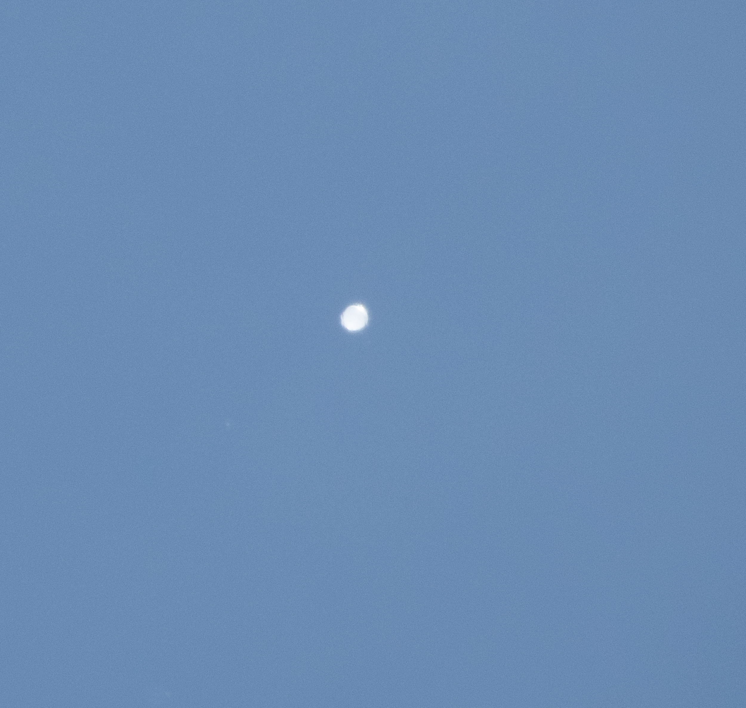
Horus 58 at 33 km altitude, seen from the ground at Eudunda, SA
After burst, the chase teams headed south of Eudunda, where they met up with Steve VK5ST who was also out chasing. The payloads eventually landed a fair way into a property, but thanks to the landowner (Condor Laucke, of Laucke Mills), they were able to gain access and recover the payloads.

Payload Results
All payloads performed almost perfectly on this flight! The only small issue was seen on the Horizon-facing imagery payload, which was slightly out of focus (an easy fix once back on the ground). The Nadir (downward) facing payload took many high quality images of the ground underneath the launch site, which proved very useful to the SHSSP 2023 participants for reasons to be discussed later!
The radiation sensor payload data clearly showed an increase in radiation levels as the payloads increased in altitude to ~20 km, and then a decrease in levels above that. This effect is known as the ‘Pfotzer-Regener Maximum’. All the sensor data from this flight can be seen on an interactive dashboard available here.
The LoRaWAN payload also performed well, being received as far away as Portland, Victoria: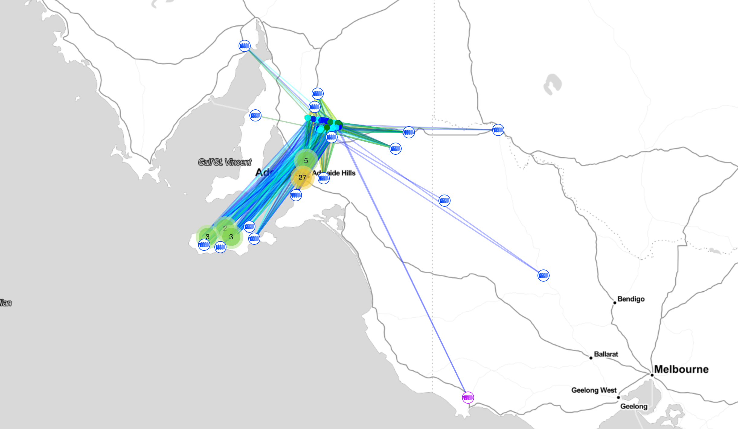
Receiver Statistics – Horus Binary Telemetry
We saw a great turnout of receivers on this launch, with 30 unique callsigns receiving the Horus Binary telemetry. Thanks to all that helped receive telemetry from this flight!
Horus 58 - HORUS V2 Receiver Statistics
| Callsign | Received Packets | Percentage of Flight Received | First-Received Altitude (m) | Last-Received Altitude (m) |
|---|---|---|---|---|
| BARC-RRR | 1465 | 76.9% | 3441 | 524 |
| VK3BKQ-PORTARLINGTON | 1 | 0.1% | 31860 | 31860 |
| VK3JUG | 7 | 0.4% | 16531 | 17237 |
| VK3OF | 862 | 45.3% | 12681 | 11840 |
| VK3TNU pi3-2 | 772 | 40.5% | 20600 | 10465 |
| VK3TRO | 7 | 0.4% | 25023 | 30667 |
| VK5AKK | 1735 | 91.1% | 1213 | 3056 |
| VK5APR | 1620 | 85.1% | 1344 | 1443 |
| VK5ARG | 1855 | 97.4% | 706 | 1130 |
| VK5CLD | 1592 | 83.6% | 926 | 524 |
| VK5CV | 1167 | 61.3% | 3465 | 1964 |
| VK5DMC | 563 | 29.6% | 27366 | 2466 |
| VK5DSP | 1459 | 76.6% | 3761 | 1934 |
| VK5DSP-2 | 1441 | 75.7% | 3225 | 4563 |
| VK5FD | 1754 | 92.1% | 3594 | 888 |
| VK5GA | 1596 | 83.8% | 792 | 1767 |
| VK5GY | 1771 | 93.0% | 683 | 1856 |
| VK5IS | 1869 | 98.2% | 664 | 1180 |
| VK5KX-i5 | 1890 | 99.3% | 312 | 915 |
| VK5LJG | 1819 | 95.5% | 664 | 1443 |
| VK5LJG-9 | 1671 | 87.8% | 313 | 400 |
| VK5LN | 1377 | 72.3% | 4771 | 6499 |
| VK5LO | 264 | 13.9% | 848 | 8135 |
| VK5LO-5 | 1533 | 80.5% | 8241 | 1520 |
| VK5NEX | 1776 | 93.3% | 1933 | 1856 |
| VK5NTM | 1868 | 98.1% | 848 | 407 |
| VK5QI-9 | 1835 | 96.4% | 313 | 524 |
| VK5RK | 1783 | 93.6% | 2388 | 972 |
| VK5RR | 3 | 0.2% | 2196 | 2273 |
| VK5RR-VK5FO | 1313 | 69.0% | 6597 | 972 |
| VK5ST-4 | 1737 | 91.2% | 1168 | 1103 |
| VK5ST-9 | 1158 | 60.8% | 500 | 426 |
| VK5TRM | 1850 | 97.2% | 1144 | 972 |
| VK5ZM | 1828 | 96.0% | 312 | 1180 |
| vk5mhz | 1230 | 64.6% | 11597 | 2438 |
Horus 58 - HORUSGEIGER Receiver Statistics
| Callsign | Received Packets | Percentage of Flight Received | First-Received Altitude (m) | Last-Received Altitude (m) |
|---|---|---|---|---|
| BARC-RRR | 1723 | 90.3% | 1623 | 938 |
| VK3OF | 186 | 9.7% | 14325 | 18409 |
| VK3TNU pi3-2 | 676 | 35.4% | 20638 | 10493 |
| VK3TNU pi3-3 | 915 | 47.9% | 12650 | 11374 |
| VK5ARG | 1857 | 97.3% | 717 | 550 |
| VK5DSP-2 | 1372 | 71.9% | 7423 | 2113 |
| VK5GY | 25 | 1.3% | 5632 | 6096 |
| VK5LJG | 1826 | 95.7% | 692 | 1596 |
| VK5LJG-9 | 1838 | 96.3% | 313 | 397 |
| VK5QI-1 | 1738 | 91.0% | 806 | 1859 |
| VK5QI-9 | 1816 | 95.1% | 313 | 423 |
| VK5ST-4 | 1859 | 97.4% | 671 | 911 |
| VK5ST-9 | 1172 | 61.4% | 481 | 397 |
| VK5ZM | 1824 | 95.5% | 312 | 1125 |
Receiver Statistics – Wenet Imagery
A special thanks goes to the 7 stations that received and uploaded imagery during the flight, with a few stations setting up to receive both imagery payloads at once. Being able to see live imagery from the flight on https://ssdv.habhub.org/ really adds something special to the experience!
Outward-Facing Imagery
VK5KX-2: 140407 packets (34.28 MB)
VK5QI-9: 127137 packets (31.04 MB)
VK5DSP: 80707 packets (19.70 MB)
VK3TNUpi4-2: 31072 packets (7.59 MB)
VK5CLD: 642 packets (0.16 MB)
VK5PW: 4969 packets (1.21 MB)
Nadir-Facing Imagery
VK5LO: 15495 packets (3.78 MB)
VK5QI-9: 182410 packets (44.53 MB)
VK5PW: 140122 packets (34.21 MB)
VK3TNUpi4-1: 31590 packets (7.71 MB)
VK5KX: 245956 packets (60.05 MB)
VK5DSP: 4614 packets (1.13 MB)
Conclusion
Horus 58 was another highly successful flight, and provided valuable testing for the SHSSP 2023 launch. Thanks again to all who participated in the flight, through helping out at the launch site, chasing, or receiving telemetry.
Stay tuned for a report on the SHSSP 2023 launch!
Horus 58 - Flight Statistics
| Metric | Result |
|---|---|
| Flight Designation: | Horus 58 |
| Launch Date: | 2023-01-15 00:03Z |
| Landing Date: | 2023-01-15 02:17Z |
| Flight Duration: | ~2 hours |
| Launch Site: | -34.02945, 138.69169 |
| Landing Site: | -34.23788, 139.13095 |
| Distance Traveled: | 46.6 km |
| Maximum Altitude: | 33,359 m |